 Print - Provides for printing of the current map display.
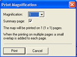
Magnification - The drop down arrow provides a selection from 1 to 10. Be aware that the number of printed pages is the square of the magnification. For example, choosing a magnification of 4 will result in a print on 16 pages. The window will display the number of required pages. A magnification of 10 equates to 100 pages of print.
Summary Page - Check this box to print a summary page with the map print.
The summary will include such things as horizontal resolution, vertical resolution, magnification, points plotted, drawing area width, drawing area height, colours, centre longitude, centre latitude, maxplot and scale.